North Texas doesn’t flood like the coast, and it doesn’t flood like the Hill Country either. Here’s the actual combination of rainfall, geography, soil, and drainage design behind why North Texas floods so fast — with the local data and NWS research to back it up.
Why North Texas Floods So Fast: The Short Answer
North Texas floods quickly because of how the rain arrives, not just how much of it falls. Thunderstorms here regularly dump two to three inches of rain in under two hours, and that water lands on clay-heavy soil that barely absorbs it and on a rapidly built-up Metroplex where rooftops, driveways, and streets replace what used to be open prairie. With nowhere to soak in, the water runs off fast, fills small creeks within minutes, and backs up at low points — intersections, underpasses, and low-water crossings — long before a river ever officially “floods.” That’s why North Texas floods so fast even in neighborhoods that have never been mapped as high flood risk.
It’s the Rainfall Rate, Not the Yearly Total, That Causes Flash Flooding
The Dallas-Fort Worth Metroplex receives roughly 37 inches of rain in an average year — not an extreme number by national standards. The problem is timing. North Texas thunderstorms are notorious for dropping massive amounts of water in short windows; a storm cell delivering close to three inches of rain in 90 minutes is not unusual here, and the National Weather Service’s Fort Worth office documents several of these fast, high-intensity rain events across the Metroplex every year. When that much rain falls that quickly, storm drains and creek channels simply can’t move it out fast enough, and water finds the lowest available point — a street intersection that becomes a pond, or a slab foundation pushed against by water pressure building up in saturated clay soil outside.
North Texas Sits at the Northern Edge of “Flash Flood Alley”
Meteorologists use the term “Flash Flood Alley” to describe a crescent-shaped stretch of Texas running along the I-35 corridor from North Texas down through Austin and San Antonio toward the Texas Hill Country — widely regarded as one of the most flash-flood-prone regions in North America. The Texas Water Development Board points to steep terrain, shallow soil, and high-intensity rainfall rates as the core drivers of this risk across the corridor. Dallas-Fort Worth sits at the flatter, northern end of that same band. The most extreme, fastest-rising river surges tend to happen further south and west in the Hill Country’s steep terrain, but the same basic ingredient — intense rain arriving faster than the ground and drainage systems can handle — is exactly why North Texas floods so fast during its own storm seasons, especially in spring and late summer.
Sources: The Dallas Morning News, WFAA, Texas Water Development Board.
What NWS Research Says About North Texas Flash Floods Specifically
The National Weather Service’s Fort Worth forecast office has studied local flash flood patterns directly, and its research is clear on one point: flash flooding kills more people annually than almost any other severe weather type, in large part because it develops with so little advance warning. A flash flood, by the American Meteorological Society’s definition NWS forecasters use, is a flood that rises and falls rapidly with little or no warning, usually from intense rainfall concentrated over a fairly small area — a description that fits North Texas thunderstorm cells almost exactly. That’s a meaningfully different hazard than a slow-rising river flood days after a storm, and it’s why North Texas emergency alerts so often use the word “flash.”
Clay Soil, Flat Terrain & Urban Runoff — DFW’s Drainage Problem
Three local factors compound the rainfall-rate problem across North Texas:
Clay-heavy soil
Much of the Metroplex sits on expansive clay soil that absorbs water slowly and swells when saturated, so even moderate rain quickly turns into surface runoff instead of soaking in.
Flat terrain, fast-filling creeks
DFW’s relatively flat landscape means water doesn’t have far to travel before it reaches a creek bed or drainage easement — and small, normally shallow creeks can rise several feet within minutes during an intense storm cell.
Rapid urban development
Decades of rooftops, driveways, and parking lots replacing open prairie across cities like Frisco, McKinney, Prosper, and Celina has sharply increased impervious surface area, so more storm runoff moves faster toward the same drainage systems than it did a generation ago.
Recent Examples: How Fast North Texas Flooding Developed in 2026
These aren’t hypothetical risks — they’ve played out repeatedly across the Metroplex this year alone:
1–2 Inches of Rain, Then a Flash Flood Warning Within Hours
An overnight storm dropped 1 to 2 inches of rain over Dallas County before the NWS Fort Worth office issued a flash flood warning — with another 1 to 2 inches still forecast on top of it. The warning extended across more than a dozen communities, including Arlington, Grand Prairie, Mesquite, DeSoto, Cedar Hill, Duncanville, Lancaster, Balch Springs, and Seagoville.
Stalled Storms Over Tarrant, Dallas & Rockwall Counties
Thunderstorms stalled in place for more than an hour over parts of eastern Tarrant, Dallas, and Rockwall counties, producing enough concentrated rainfall to push creeks and streams up quickly and trigger flash flood warnings across the corridor.
Renewed Flooding Concerns in Northeast Tarrant County
After several inches of rain fell over Keller, North Richland Hills, Watauga, and Haltom City, meteorologists closely monitored the area for follow-on flooding as additional storms and lightning moved through.
Sources: CBS News Texas, National Weather Service Fort Worth office, Texas Storm Chasers.
Which North Texas Areas Flood Fastest
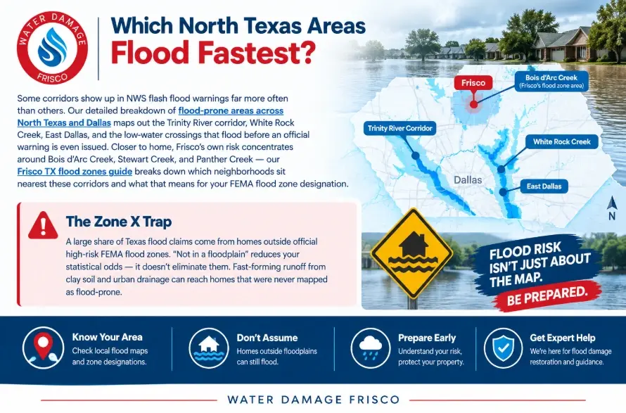
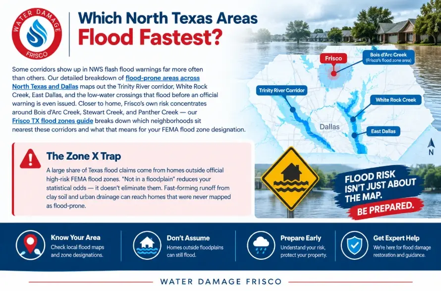
Some corridors show up in NWS flash flood warnings far more often than others. Our detailed breakdown of flood-prone areas across North Texas and Dallas maps out the Trinity River corridor, White Rock Creek, East Dallas, and the low-water crossings that flood before an official warning is even issued. Closer to home, Frisco’s own risk concentrates around Bois d’Arc Creek, Stewart Creek, and Panther Creek — our Frisco TX flood zones guide breaks down which neighborhoods sit nearest these corridors and what that means for your FEMA flood zone designation.
How Fast Is Too Fast? Why “Turn Around, Don’t Drown” Exists
Speed is exactly what makes North Texas flash flooding dangerous to drivers, not just homeowners. Just six inches of moving water is enough to knock an adult off their feet, and around twelve inches — about a foot — can float most passenger vehicles. Low-water crossings and low points on North Texas highways can go from dry to dangerous in minutes as storm drains and culverts get overwhelmed, sometimes worsened by debris-clogged drains or nearby road construction. The National Weather Service’s core rule during any North Texas flash flood warning is simple: never drive or walk into moving water, no matter how familiar the road looks.
How North Texas Homeowners Can Prepare for Fast-Moving Storms
- Sign up for NWS flash flood alerts through Wireless Emergency Alerts or NOAA Weather Radio — with flash floods, warning time is measured in minutes, not hours.
- Grade your yard and extend downspouts away from the foundation; DFW’s clay soil makes proper drainage around the slab one of the highest-value fixes a homeowner can make.
- Know your FEMA flood zone using the FEMA Flood Map Service Center — and remember that “outside the mapped zone” is not the same as “flood-proof.”
- Review your insurance before storm season, not during it. Standard homeowners policies typically exclude rising floodwater; see our flood insurance guide for DFW homeowners for what a separate NFIP or private policy actually covers.
- Build a full storm season checklist — our storm season flood prep checklist for Frisco TX walks through drainage responsibilities, HOA detention ponds, and emergency supplies specific to North Texas homes.
- Have a restoration plan ready. If water does get in, our DFW storm flooding response guide covers exactly what to do in the first hour, before the 24–48 hour mold window closes.
Official Texas & Federal Flood Resources
- Texas Water Development Board — State & Regional Flood Planning — Texas’ official state flood plan and regional flood risk data.
- Texas Division of Emergency Management (TDEM) — statewide flood response updates and damage reporting.
- Texas Department of Insurance — guidance on flood coverage options for Texas homeowners.
- National Weather Service — Fort Worth/Dallas Office — live flash flood watches and warnings for North Texas.
- FEMA Flood Map Service Center — look up your property’s official flood zone designation.
- Turn Around, Don’t Drown — NWS safety campaign on moving floodwater.
Storm Water Already in Your Home?
Water Damage Frisco provides 24/7 emergency water extraction and flood damage restoration across Frisco, McKinney, Prosper, Carrollton, Plano, Allen, Celina, and the rest of North Texas — 60-minute guaranteed response.
Get Emergency Help NowFrequently Asked Questions
Why does North Texas flood so fast compared to other regions?
North Texas thunderstorms can drop close to three inches of rain in under two hours — a rate the region’s clay-heavy soil and storm drainage systems weren’t built to absorb quickly. Combined with flat terrain that lets runoff reach creeks almost immediately, this produces flash flooding far faster than a slow-building river flood.
Is North Texas part of “Flash Flood Alley”?
Dallas-Fort Worth sits at the northern edge of the informally named “Flash Flood Alley,” a corridor running along I-35 from North Texas through Austin and San Antonio toward the Hill Country. The most extreme river surges happen further south and west, but the same intense-rainfall, fast-runoff pattern contributes to how often flash flood warnings hit the Metroplex.
Can my home flood even if I’m not in a mapped FEMA flood zone?
Yes. A significant share of Texas flood insurance claims come from properties outside official high-risk flood zones. Being outside a mapped zone lowers your statistical risk — it does not mean your property can’t flood during an intense, fast-moving North Texas storm.
How much rain does it take to cause flash flooding in DFW?
There’s no single threshold, but two to three inches of rain within an hour or two is a common trigger for North Texas flash flood warnings, especially when the ground is already saturated from previous rainfall or when storms stall in place over one area.
How fast can moving floodwater become dangerous?
Very fast. Just six inches of moving water can knock an adult off their feet, and roughly twelve inches can float a passenger vehicle. That’s why the National Weather Service’s core safety message during any flash flood warning is to never drive or walk into moving water.
What should I do first if my North Texas home starts flooding?
Get people and pets out of the affected area, and only shut off power at the breaker if you can reach it safely and dry. Our DFW storm flooding response guide walks through the full first-hour sequence, from safety through documentation for your insurance claim.
Serving Frisco, McKinney, Plano, Prosper, Celina, Carrollton, and all of North Texas — call (945) 297-3238 for 24/7 emergency flood response.