

Flood Prone Areas in North Texas And Dallas: Where Flooding Happens Most
A breakdown of the rivers, creeks, and low-lying zones across the Dallas-Fort Worth Metroplex most likely to flood — and what that means if you live nearby.
Why North Texas Floods So Easily
North Texas sits in a flash-flood-prone climate zone: intense, fast-moving thunderstorms can dump several inches of rain in a matter of hours, and much of the region’s older infrastructure and clay-heavy soil doesn’t drain quickly. Add the Trinity River watershed running straight through the middle of the Metroplex, and you get a pattern that repeats almost every storm season — heavy rain, saturated ground, and rapid water rise along creeks, low-water crossings, and urban streets.
The Metroplex averages roughly 37 inches of rain a year, but the yearly total isn’t really the problem — the rate is. It’s not unusual for a North Texas storm cell to drop close to three inches of rain in under two hours, and the National Weather Service’s Fort Worth office tracks several of these fast-hitting rain events across the region every year. When rainfall arrives that quickly, storm drains and saturated clay soil simply can’t keep pace, and water backs up at the lowest available point — an intersection, a creek bank, or a low-lying foundation.
North Texas and “Flash Flood Alley”
Meteorologists and local news outlets increasingly refer to a crescent-shaped band of Texas — running along the I-35 corridor from North Texas down through Austin and San Antonio toward the Hill Country — as “Flash Flood Alley,” one of the most flash-flood-prone regions in North America. Dallas-Fort Worth sits at the northern edge of this corridor, and while the steepest terrain and fastest river rises are further south and west, the same combination of intense rainfall rates and fast runoff shows up across the Metroplex during major storm systems.
The Texas Water Development Board points to steep terrain, shallow soil, and high-intensity rainfall as the core drivers of this risk pattern statewide, and North Texas experiences a flatter but still fast-draining version of the same setup — which is part of why flash flood warnings hit Dallas, Tarrant, Collin, and Denton counties so frequently during the spring and late-summer storm seasons.
Sources: The Dallas Morning News, WFAA, Texas Water Development Board.
Areas With the Highest Flood Risk in North Texas
These are the zones that show up again and again in NWS flood warnings, river flood advisories, and local news coverage of North Texas flooding:
Trinity River Corridor (Dallas) River Flooding
The Trinity River runs through the heart of Dallas and has been placed under river flood warnings multiple times, including extended warnings that kept low-lying areas at risk for days after a storm passed. Neighborhoods and roadways near the river’s floodway are especially exposed.
White Rock Creek (Dallas) Creek Flooding
White Rock Creek has been under river flood warnings alongside the Trinity River during major North Texas storm systems, affecting nearby residential areas and parkland.
East Dallas & Seagoville Flash Flooding
East Dallas has recorded some of the most extreme single-event rainfall totals in the region’s history, with entire neighborhoods submerged and water rescues needed. Seagoville and surrounding Dallas County communities have faced similar flash flooding during the same storm systems.
Lancaster, Mansfield & South Fort Worth Flash Flooding
Southern Dallas and Tarrant County — including Lancaster, Mansfield, and parts of south Fort Worth — have repeatedly seen high-water rescues and road closures during flash flood events, with rainfall totals sometimes exceeding 5-6 inches in a single morning.
Keller, North Richland Hills & Northeast Tarrant County Flash Flooding
Northeast Tarrant County communities — including Keller, North Richland Hills, Watauga, and Haltom City — have seen renewed heavy-rain flooding concerns in 2026, with local storm systems repeatedly stalling over the same corridor and prompting close monitoring for follow-on flooding.
Denton & Wise County Corridor Flash Flooding
The northwestern side of the Metroplex, along the Red River and through Denton and Wise counties, frequently sees the heaviest rain totals when storm systems track through North Texas — a pattern flagged repeatedly in NWS forecasts.
Low-Water Crossings Metro-Wide High Risk
Beyond named rivers and creeks, dozens of low-water road crossings throughout Dallas, Collin, Denton, and Tarrant counties flood before an official warning is even issued. These are consistently where water rescues and vehicle incidents happen during heavy rain.
Sources: National Weather Service Fort Worth office, CBS News Texas, NBC 5 DFW, and local flood warning archives.
Recent North Texas Flood Events (2026)
North Texas flooding isn’t a one-time story — it’s a recurring seasonal pattern. Here’s what’s happened across the Metroplex so far in 2026:
Renewed Flooding Concerns in Northeast Tarrant County
After several inches of rain fell over Keller, North Richland Hills, Watauga, and Haltom City, meteorologists closely monitored the area for additional flooding as more storms and lightning moved through the region.
Overnight Flash Flood Warning Across Dallas County
An overnight storm dropped 1 to 2 inches of rain before the NWS Fort Worth office issued a flash flood warning, with another 1 to 2 inches forecast on top of that. The warning stretched well beyond Dallas proper, covering Arlington, Grand Prairie, Mesquite, DeSoto, Cedar Hill, Duncanville, Lancaster, Balch Springs, and Seagoville, among other communities.
Stalled Storms Trigger Warnings in Tarrant, Dallas & Rockwall Counties
Thunderstorms stalled over parts of eastern Tarrant, Dallas, and Rockwall counties for more than an hour, producing enough rainfall to push creeks and streams up and prompt flash flood warnings across the corridor.
Sources: CBS News Texas, National Weather Service Fort Worth office, Texas Storm Chasers.
Official Government Flood Resources
For real-time, authoritative flood information — not third-party aggregators — use these official sources:
- National Weather Service — Fort Worth/Dallas Office — official flood watches, warnings, and forecast discussions for North Texas.
- NWS Advanced Hydrologic Prediction Service (North Texas Rivers) — live river and creek gauge levels, including the Trinity River.
- FEMA Flood Map Service Center — look up your property’s official flood zone designation.
- NWS Flood Safety — official guidance on what to do before, during, and after a flood.
- USGS Texas Real-Time Water Data — federal stream and river gauge network for Texas.
- City of Dallas Office of Emergency Management — local emergency alerts and flood preparedness resources.
Dallas County Flood Mitigation & Insurance Snapshot
Beyond warnings and storm history, county-level mitigation and insurance data give a sense of how seriously flood risk is treated on the ground in Dallas County:
Source: OpenFEMA Hazard Mitigation Assistance data and the USACE National Levee Database, compiled August 2026.
How to Check the Flood Zone for Any Dallas Address
Flood risk in Dallas isn’t limited to the well-known corridors along the Trinity River or White Rock Creek. Commercial buildings, office parks, and residential streets throughout the Stemmons Freeway area, the Design District, and dozens of other neighborhoods sit inside or near mapped flood zones — and the only way to know for certain is to look up the address directly. Here’s how to do it in under two minutes, using the same official source insurers, lenders, and contractors rely on.
Open the FEMA Map Service Center
Go to FEMA’s official Flood Map Service Center — the same national database used for insurance and permitting decisions.
Enter the Full Street Address
Type the complete address — street number, street name, city, and ZIP — for the most accurate match to the current Flood Insurance Rate Map (FIRM).
Read the Zone Designation
Zones starting with “A” or “V” carry mandatory flood insurance requirements in most cases. Zone “X” means reduced risk — but not zero risk, especially during North Texas flash-flood events.
Live FEMA Flood Map — Look Up Any Address
Interactive tool provided by FEMA (msc.fema.gov). Opens in a new tab — FEMA’s site does not allow embedding, so this links you straight to the official lookup.
DFW Flood-Risk Corridors at a Glance
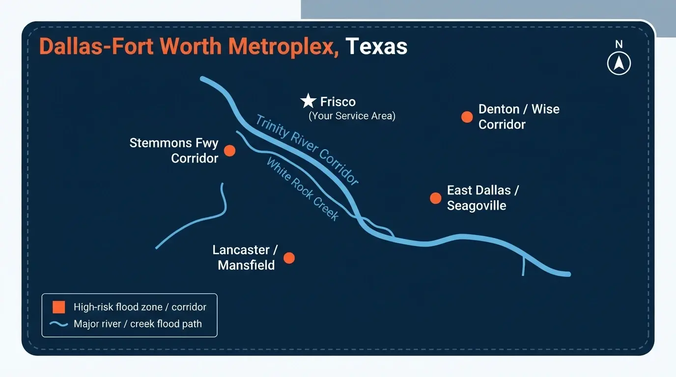
Illustrative overview based on NWS and FEMA flood-warning history for the Dallas-Fort Worth Metroplex. Not a substitute for an official FEMA flood zone lookup.
What This Means If You’re in Frisco, McKinney, Prosper, or Carrollton
Frisco and its neighboring cities sit north of the highest-risk Dallas corridors, but they’re not exempt. The same storm systems that flood the Trinity River and East Dallas regularly push through Collin and Denton counties too, and Frisco-area buildings carry a real long-term flood probability even outside a mapped FEMA flood zone. Localized flash flooding along smaller creeks and low-water crossings can happen anywhere in the Metroplex during an intense storm — proximity to a “named” flood zone isn’t the only risk factor.
How to Prepare If You’re in a Flood-Prone Area
- Know your zone. Check the Texas Flood Information Viewer or FEMA’s flood map service to see your property’s specific designation.
- Sign up for NWS alerts. Wireless Emergency Alerts and NOAA Weather Radio give the fastest official notice of a flood or flash flood warning.
- Never drive through a flooded roadway. Just 6 inches of moving water can sweep away a person, and 12 inches can move a car.
- Elevate valuables and utilities if your property is in a known low-lying or creek-adjacent area.
- Have a restoration contact ready. In flood-prone zones, the speed of your response after water enters a home directly affects how much damage — and mold risk — you end up with.
Live in a Flood-Prone Area of North Texas?
Water Damage Frisco provides 24/7 emergency water extraction and flood damage restoration for Frisco, McKinney, Prosper, Carrollton, The Colony, and surrounding North Texas communities.
Get Emergency Help Call us anytime — we respond fast.Frequently Asked Questions
What are the most flood-prone areas in North Texas?
The Trinity River corridor and White Rock Creek in Dallas, East Dallas and Seagoville, southern Dallas/Tarrant County cities like Lancaster and Mansfield, northeast Tarrant County cities like Keller and North Richland Hills, and the Denton/Wise County corridor along the Red River are among the areas that see repeated flood warnings and flash flooding during major storm systems.
Is Frisco considered a high-flood-risk city?
Frisco isn’t among the highest-risk zones in the Metroplex, but it isn’t flood-proof either. Localized flash flooding along creeks and low-water crossings can occur during intense storms, and flood-risk modeling estimates a meaningful long-term probability of flooding for area buildings, including those outside mapped FEMA flood zones.
Why does North Texas flood so quickly during storms?
North Texas thunderstorms can be intense and fast-moving, dropping several inches of rain in a short window — sometimes close to three inches in under two hours. Combined with clay-heavy soil that drains slowly and an extensive network of creeks and low-water crossings, this leads to rapid flash flooding even without a named river nearby.
What is “Flash Flood Alley,” and is North Texas part of it?
Flash Flood Alley is the informal name for a crescent-shaped stretch of Texas along the I-35 corridor, running from North Texas down through Austin and San Antonio toward the Hill Country. Dallas-Fort Worth sits at the northern end of this corridor, and while the fastest and most extreme river rises tend to happen further south and west, the same steep-rainfall, fast-runoff pattern contributes to how often flash flood warnings hit the Metroplex.
What should I do if I live near a flood-prone creek or river in North Texas?
Sign up for NWS weather alerts, know your property’s flood zone designation, keep an emergency plan ready, and have a water damage restoration contact on hand so you can respond immediately if flooding does occur — the first 24-48 hours are critical for preventing mold and structural damage.
How do I find the flood zone for a specific Dallas address, like a commercial building?
Use FEMA’s Flood Map Service Center at msc.fema.gov, enter the full street address, and the tool will return the official FIRM flood zone designation for that exact property. This works for residential addresses, commercial buildings, and office parks anywhere in Dallas County, including areas along the Stemmons Freeway corridor near the Trinity River floodway.